Images obtained by satellites and high-altitude aircraft give engineers and
scientists a tool to study landforms, vegetation health patterns, environmental
pollution, and other effects of human activities on the planet's surface.
Satellites and high-altitude aircraft equipped to record scenes of the Earth
use both visible and invisible parts of the electromagnetic spectrum.
Near-infrared light is invisible to the human eye, but adding it to these images
allows scientists to "see" the surface of the Earth in other than natural
colors. The result is "color-infrared" photography.
The electromagnetic spectrum is the scientific term for the collective types
of light and energy emitted from the Sun. The part of the spectrum visible to
the human eye is the normal rainbow of colors we see every day. Passing sunlight
shining through a prism separates white light into individual colors, just as
sunlight through raindrops creates a rainbow. More technically, a prism divides
light into its component wavelengths. Ripples on a lake can be close together or
far apart and are analogous to light wavelenths and how closely they are spaced.
Other parts of the spectrum—such as the invisible near-infrared
wavelengths—can be recorded by either electronic sensors or special photographic
films sensitive to these wavelengths. These sensors and films record the energy
reflected by the ground and the Sun's spectral energy. The color-infrared film
images referred to in this fact sheet should not be confused with electronic
thermography (thermal recordings), a process in which long-wave or
"far-infrared" radiation is electronically detected and subsequently displayed
at visible wavelengths. Near-infrared and visible wavelengths that are
simultaneously recorded combine to provide a unique view of the Earth's
vegetation and other features of the planet's surface.
This unique aerial view, created by a combination of wavelengths, gives
scientists a means to better understand what is happening on the Earth's
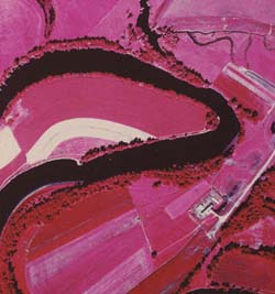
surface. For example, leaves of healthy, growing vegetation reflect a high level
of near-infrared wavelengths and appear red on color-infrared film. Unhealthy or
dormant vegetation may appear light red or a light shade of blue-green (cyan),
depending on the plant's degree of good health. These color distinctions make
color-infrared photographs useful in assessing the health of plants. Water, on
the other hand, absorbs near-infrared wavelengths and appears black in the
image. Water with varying amounts of suspended particles appears as shades of
blue. Also, near-infrared wavelengths penetrate atmospheric haze and result in
clear, crisp images. This is an important consideration when collecting
satellite images and high-altitude aerial photographs.
Satellite electronic sensors and aerial color-infrared films both record
visible and near-infrared wavelengths, but each of these systems requires
different laboratory processes. Here is how they work.
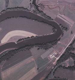
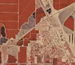
Color-infrared photograph—near same area
Color-Infrared Photographs
Both standard-color and color-infrared films are manufactured to have three
distinct layers, or emulsions. Each layer is sensitive to different wavelengths
or energy. Standard-color film emulsions normally record the visible wavelengths
as red, green, and blue. After the picture has been taken, chemical processing
of the film generates cyan, magenta, and yellow dyes proportional to the amount
of exposure given each layer. Color pictures result when the human eye views the
varying combinations of the three dye layers. Color-infrared film has a yellow
filter over the three emulsion layers to block ultraviolet (UV) and blue
wavelengths. Processing color-infrared film after exposure produces yellow,
magenta, and cyan dyes. The near-infrared wavelengths and the lack of UV and
blue wavelengths result in a clear, crisp color-infrared image. Green, healthy
vegetation has a high reflection level of near-infrared wavelengths and appears
red on the processed film; red objects with very low near-infrared reflection
appear green; green objects with very low near-infrared reflection appear blue;
and blue objects with very low near-infrared reflection appear black.
The Federal Government has color-infrared photographic coverage of the entire
United States from a high altitude (40,000 feet) and is obtaining similar
coverage at a lower altitude (20,000 feet) for many States.
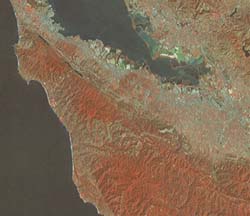
Color-Infrared Composite Images
Another type of color-infrared image is the color-infrared composite of
multispectral data collected by electronic sensors on satellites such as
Landsat. These sensors record the light levels of Earth's reflected energy (from
blue/green wavelengths through infrared wavelengths) and transmit these data in
digital format to the ground in sets of four or seven wavelength-dependent bands
for each typical Landsat scene. On the ground, the digital image data may be
converted to hardcopy images similar in appearance to conventional
color-infrared photographs. Computerized image-recording devices process the
bands of green, red, and near-infrared digital data, exposing conventional color
film or paper with blue, green, and red light, respectively. In the resulting
image, growing healthy vegetation appears red, clear water appears black,
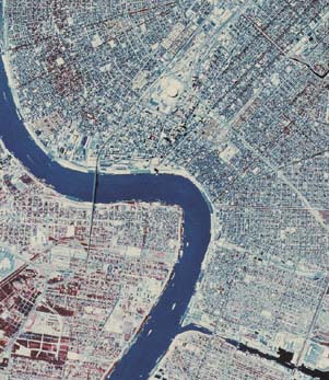
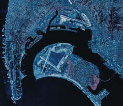
sediment-laden water appears light blue, and urban areas appear blue-gray.
How to Find More Information
For information about ordering color-infrared composites or color-infrared
aerial photographs, please contact any Earth Science Information Center, or call
1-888-ASK-USGS.
More information on color-infrared technology is available from many libraries.
Among the many books exploring this subject are the following:
M.M. Thompson's Maps for America, U.S. Geological Survey (Government Printing Office,
Washington, D.C., 1987) , and Robert K. Holtz's The Surveillant Science:
Remote Sensing of the Environment (John
Wiley and Sons, 1985). For more technical information, you could consult the
Manual of Remote Sensing, published by the American Society of Photogrammetry and Remote
Sensing, 5410 Grosvenor Lane, Bethesda, MD 20814-2160.
For information on other USGS products and services, call 1-888-ASK-USGS, use
the Ask.USGS fax service, which is available 24 hours a day at 703-648-4888, or
visit the general interest publications Web site on mapping, geography, and
related topics at mac.usgs.gov/mac/isb/pubs/pubslists/.
Lansat color-infrared composite—Williams, Calif., quadrangle.
For additional information, visit the ask.usgs.gov Web site or the USGS home page
at usgs.gov.
Kaynak
http://mac.usgs.gov/mac/isb/pubs/factsheets/fs12901.html